Thursday 27 March 2014

A stunning nature walk in the Gearagh, Cork's flooded forest


  • An easy, level walk, which you can shorten or lengthen as you wish
  • Easily accessible from car-park on Macroom-Inchigeela road
  • Great variety of natural habitats, with much birdlife visible
  • A wooden hide available for bird-watchers to use
  • Much folklore about the Gearagh to add interest
  • An informative map-board at the car-park
  • Especially beautiful in Spring and Summer

 The start-point for this walk can be reached, either by car, bike or on foot, by taking the turn-off towards Inchigeela / Ballingeary just to the south of Macroom, and travelling along there for 3km. You'll see a sign on the left saying 'Gleann Alainn na Laoi', and 100m further on you turn into the large car park. (Just a note of caution : don't leave anything valuable visible in your car, eg phones / car music systems, this applies everywhere really). This is the start for the Gearagh Walk (Gearagh is from the Irish 'An Gaorthadh', meaning wooded river / river-valley).

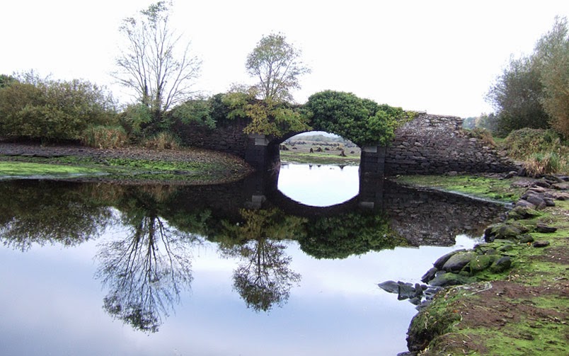
 The full circuit of the nature reserve which I will describe is about 6.5km (4.5 miles) in length. You must climb a stile at the car park, and keep straight ahead along a wide, well-surfaced path, which crosses an old stone bridge very shortly. This is good place to get a view of the lake spreading out on either side, which was created in the 1950's by the ESB as part of the Lee Hydroelectric Scheme. One of the main channels of the Lee formerly flowed beneath these attractive arched stone bridges, and the flow through here is quite something even now (swimming strongly advised against!). Due to local efforts, what remained after the flooding of the area's post-glacial alluvial forests (unique in Ireland, very rare in Western Europe) has been preserved as a Nature Reserve since the 1970's. The densest area of oak forest and twisting channels lies upstream and is not open to visit, being quite dangerous to enter.

 Your walk continues straight ahead across more stone bridges, where you can look out for swans (quite a sight coming in to land, I saw one yesterday). This lane was formerly the main road from Macroom to Dunmanway, but now only carries walkers and some cyclists. Due to the very heavy rain we had recently, there were occasions (even earlier this week) when the path was impassable after about a quarter of a mile (about 0.4 kms) as the lake had flooded the path. But levels are now lower, I checked them today, as the waters have been run through the Carrigadrohid turbines (hydroelectric station).

 The path continues as a causeway across the lake / marshes, and look out for wood sorrel growing in the Spring (I saw some today) in the shade of trees. Eventually, after about 1.2 kms max walking along a tree-lined path, you'll reach a crossroads. You can detour to the left here for some minutes, passing on your left a large lake-like enclosed expanse of water, where lately I saw a little egret. They look initially like a heron, being quite large, but they are in fact a purely white bird. They were rare in Ireland before the late 1990's, but their numbers are growing, and they are most common in the wetlands of Co.s Cork and Waterford. They are a beautiful sight, look out for a dazzling white form by the water's edge. Continuing on the detour, you arrive at the bird hide on your left, a two-storey wooden building accessed by a gate (please close behind you) and fully open to the public. You can climb to its upper level, and, especially with binoculars, enjoy great views of the birdlife.

Returning to the cross-roads, if you want a shorter walk, say 5km (3 miles) approx., I'd suggest going left here, and walking the 1.8kms straight across to the car park at the other side, where you just retrace your steps.

 To follow a longer looped walk (with some road walking, mostly very quiet), go straight ahead down a tree-lined avenue with water on the left (at present) and fields on your left. You'll soon pass a large tree thrown over on its side by the recent gales, though it's still budding. Continuing, you'll come to a wide open field on your left, and a hedge to your right. There's a bench here (as there is near the first set of bridges) for a handy picnic stop.

 Continue a few hundred metres, and you go through a passing place by a large field gate, and continue walking along the road. This road passes by quiet countryside which borders the nature reserve. After 0.5kms, you approach a sharp (right-angle) right turn. Before this, look to left and right for bright yellow celandines, flowering now in this spot, opening their flowers wide in sunshine.

 Following the lane, the road takes another sharp turn to the left, and then in less than 0.5kms, you take a left turn. This road takes you in about 1.5kms down to the Droumcarra to Macroom back-road.
Trees are starting to bud here now, and in Autumn you'll see sloe bushes fruiting and the bright red of hawthorn fruits too. You pass Kilmichael GAA club, which has a plaque outside commemorating the first gaelic games played in Ireland in modern times, at Kilmichael grounds in 1884.

 Coming down to the larger road after this, at a T-junction, turn left and follow the road for about 1km. It's tree-lined, and you see into the wild areas of the reserve on your left. You pass a turning to Toames to your right, and just after that you turn into a car-park and cross a stile to re-enter the nature reserve. It is 3km from here straight across the reserve to where you started. There's an attractive river with gravel beach just at this little car-park.

 Notice as you walk back all the varied habitats, from marsh to open water. Ducks, often in breeding pairs at the moment, are numerous here at present. Winter is reputed to be the best time to see wintering birds here, but there's always something to see, and  it's very beautiful. The sunlit, tree-shadowed paths of late spring and summer here are a pleasure to walk. Enjoy your walking.

 Just to say, this is more a country walk than a hill walk, but I do want to cover both, and the Gearagh is a unique place for Cork and all Irish people. Finally, spare a thought for the rapparee or highwayman, Sean Rua na Gaoire, who used to live in a tree-house in the dense, now flooded, forest in the nineteenth-century, and was known as a local Robin Hood. Where his home was is now just an open expanse of water.


Saturday 22 March 2014

An energetic climb of the highest mountain near to Cork City


  • Start-point of this walk is less than 40 mins drive from Cork City
  • Ascends the nearest 600m+ summit to the city, approx 32kms distance away
  • An energetic climb, steep in places and very invigorating
  • Can be combined with lower-level stretches of Duhallow Way for longer walk
  • A very impressive stone circle can be visited nearby

 This ascent of Musheramore (644m high), which rises as the highest of the Boggeragh mountains about 16km north of Macroom, and 32 kms north-west of Cork City, can be undertaken by itself as an energetic climb and descent taking about 1.5 hours for someone of average fitness. I've seen people running up and down it, but that wouldn't appeal to me! The splendid views from the top, ranging over most of County Cork and into the mouintains of Kerry, are worth lingering over.

 The start-point is at a road junction just by the Millstreet Country Park, which is a useful landmark for getting here. You can park easily by the entrance to the country park, and just walk back south a short way past the road branching off to the west (signposted for Knocknakilla stone circle). Your path up the mountain is to the right of a fence that runs straight up from here, and you must cross a stile to join the path. The Duhallow Way diverges to the left from your path (connecting walks involving the Duhallow Way both to the west from Millstreet, or to the east from the Glencam / general Rylane Cross area, can be researched by looking up 'Duhallow Way' on 'irishtrails.ie', including maps), but you keep straight up the mountain. After the stile at the start, be careful crossing the level boogy ground at the start : look well ahead to plan your route over the wet ground, which will involve detouring to the right and then coming back in to join the rough path straight up the mountain.

 The gain in height from where you start, at the road, to the mountain-top, is about 300m or 1000 feet, and this great western slope of Musheramore (or Mushera, as it's locally called) is a stunning feature here in the central part of Co. Cork.

 The climb is steep in places, and sometimes over wet and boggy ground, which you'll want to avoid unless you have supernaturally water-proof boots on. This is a climb on which you'll need boots with a good grip. Look well ahead when ascending, plotting your way around wet ground. Look out for stretches of heather, I usually find it grows on the driest places, and you can make a path by following it. You'll get to know the vegetation that grows on damp ground, and avoid it, as you do more hill-walking.

 It's worth taking time to look back at the views developing as you climb up, this is really a walk for a fine day without low cloud, when you can enjoy the extensive views. There is no view of the summit until you get to it, emerging onto the wide summit plateau. A good cairn marks the summit, and you have a 360-degree view of Sliabh Luachra to the north (see my post on the Paps), the Derrynasagart mountains (incl the Paps) to the west, and much of County Cork to the south and east. South-east of the summit, and less than a ten-minute walk, a large cross on a stepped-down summit is a good detour.

 Enjoy the climb, take much care descending and remember this a mountain climb as as it's a hill walk, so take warm clothing, a hot drink, and a good map.

Friday 14 March 2014

Two of the most beautiful walks in County Cork, woodland and coastal


Ship-pool Castle and Woods (see below)
  • Start-point about 1.5 miles (2.5kms) SE of Innishannon on R605 Kinsale road
  • A short walk of little over 0.5 mile total length, of no great difficulty
  • Historical interest, incl a ruined 16C castle of the Roche family
  • A beautiful walk in mainly beech woods alongside the Bandon river
  • The walk culminates in a magnificent waterfall 

Sandycove Bay to Courtaparteen (see below)
  • Start-point about 3 miles (5kms) S of Kinsale off R600 Ballinspittle road
  • A walk of little over a mile total length, on a well-defined and safe path
  • Walk first offers fine views of Sandycove Bay and Island
  • Continuing, walk gives you wide stunning views over Atlantic ocean
  • An option at the end, more challenging, to visit ruined church and village


Ship-pool Castle and Woods walk

The starting point for this walk is 1.5 miles / 2.5 kms south-east of Innishannon village on the R605 road to Kinsale, beside the ruined castle on your right above the river. There is plenty of space to park here, or to park your bike. This walk can also be reached by public transport, as a regular Bus Eireann service comes through Innishannon from both the Cork city and Bandon directions.Just walk out the R605 from Innishannon village, which means taking the first right up a steep hill at the end of the village. This road is fairly quiet, but take care as always when road-walking.

The ruined Ship-pool or Poulnalong Castle, your start-point, was built by the Roche family in 1543, said to be haunted, stands in a romantic position above a wide bend in the tidal Bandon river. It is worth quoting Mary Leland from the book 'The Lie of the Land'(1999), to give a flavour of this special place : 'the river...is crowded with reeds; the margin has been tamed in one stretch into a woodland walk. A ruined castle adds to the atmosphere which has an almost medieval texture as hills collapse into marshes and the river's golden edges merge with water-meadows and low-lying farms.' 

Simply follow the path down to the left from the castle, and it takes you along above the river for about a quarter of a mile, through beautiful woods. These beech trees are beautiful at any time of year, with their graceful trunks and branches.

Eventually the walk culminates in the sight of a splendid waterfall coming down over shelves of sloping rock, to flow into the estuary below. You simply retrace your steps to the beginning. Just be careful of any drops by the path and any warning signs.


Sandycove Bay to Courtaparteen

The start-point for this walk is about 3 miles / 5 kms to the south of Kinsale town. You take the R600 road (by car or bike) out of Kinsale town, towards the Old Head / Ballinspittle, and cross the bridge over the river Bandon estuary (which is actually the 'new' bridge!), and in about a third of a mile / 0.5 kms you come to a sign to the left for Sandycove, which involves a left and then immediately a right turn. You follow the road along the tidal inlet of Sandycove for at most 1 mile till you reach the small village of Sandycove.

Follow the road along until the road turns right to leave the sea, and park here at the head of the bay. The path simply continues straight ahead of you in a southerly direction, with a house to your right. The path winds along right beside the sea. At first you look to your left as the path rises, seeing the expanse of Sandycove Bay and Sandycove Island, the bay being sheltered from the sea, and popular with snorkellers.

As you round a point, the island gives way to one of the most spectacular views of ocean and coast in Ireland, stretching from Frower Head in the east to the Old Head to the west. I myself have seen the spouts of whales out to sea here. The whole walk is just over one mile in total, but it is a walk you must take if you love the sea.